

The hike to Mt Saksa starts from Urke down by the Hjørundfjord. The hike is three kilometers long. On these three kilometers you ascend more than 1000 meters. Map to use: Hjørundfjorden 1:50000.
Mt Saksa is located at Sunnmøre, between Norangsfjorden and the Hjørundfjord. You have a great fjord view to the two fjords all the way from the start at Urke to the summit which is located at 1073 masl.
Visit Ålesund
Visit Ålesund is the official destination company for the Sunnmøre, Geirangerfjord, Hjørundfjord and Ålesund area.
About season and other important information
GRADING – Challenging. ALTITUDE DIFFERENCE – This hike starts at approximately 40 masl (Parking lot at Urke). Highest point at approximately 1073 masl (Mt Saksa).
GUIDE – We recommend you to join a Guided Tour to Mt Saksa.
SEASON – July to Mid September, these are approximate dates that depends on the weather, temperature and the amount of snow in the mountains.
SAFETY IN THE MOUNTAINS – You should follow the Norwegian Mountain Code when hiking in Norway. It can change from summer and sunny weather to winter and frost in minutes! Always check the Weather Forecast before you go hiking. For safety reasons it is recommended to avoid hiking in Thunderstorms, in fog, in bad weather and when it is snow and ice on the trail and in the mountain! Always bring good clothes and hiking shoes. And have enough food and water in your rucksack.
NOTE – This hike is not suitable for children! This is a long and demanding hike, you should be an experienced hiker to do this hike. There are several steep, narrow and exposed sections on this hike.
NOTE – We recommend to use a map and compass on this hike since parts of the hike go in areas where there is no trail. It also often happens that Mt Saksa is shrouded in fog.
Urke – The start of the hike to Mt Saksa

The hike to Mt Saksa starts at the center of Urke. Drive to the bridge that crosses Urkeelva River, and continue for about 100 meters on the road that goes up along the west side of the river.
There you will find two parking lots (parking fee) on the left side of the road, that is where the trail to Mt Saksa starts.
You walk a short distance through the forest before reaching some open land. Here the path turns and you walk steeply up the forest towards Bentebu. On a short distance, in the forest, you can choose to walk on a tractor road instead of the trail in the forest (see pictures).
The trail in the forest is steep but well maintained with stairs made of stone on the most difficult stretches. Bentebu is a nice place to take a break and enjoy the fantastic view towards Norangsfjorden and Øye and the surrounding mountains. Mt Slogen is one of those mountains.
Bentebu – Great view towards Øye and Mt Slogen

From Bentebu, the trail continues upwards, but it is not quite as steep as down in the forest. Soon you will come out of the forest, and here the path is more gentle.
But this does not last long, because now you start on the climb up the long mountain side, and this is a long, heavy and steep hike. It is a good mix of a natural trail, stones, gravel and stairs made of stones.
In the upper part, the trail is steep. You need to be careful to not release stones when walking, it can be dangerous for those who walk behind you.
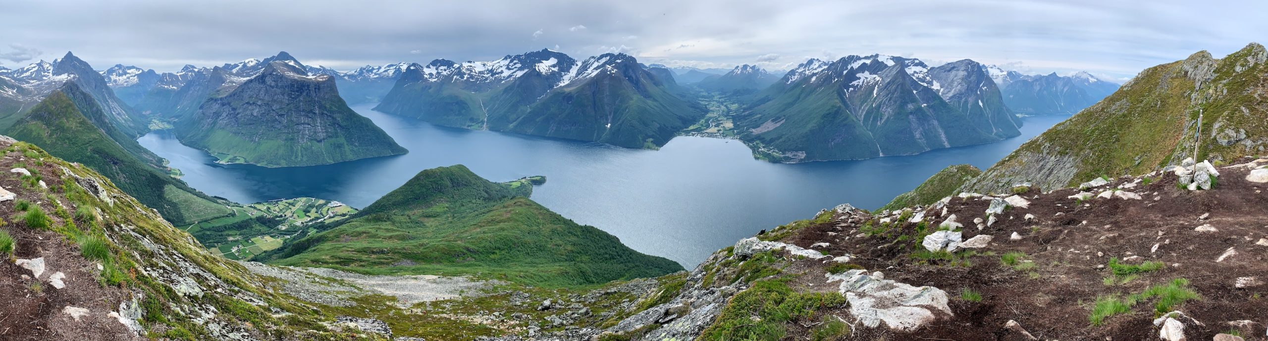
Mt Saksa – THE VIEW!

The upper part is exposed, but the trail is nice to walk on. The summit of Saksa is at 1073 masl, and the view is formidable.
From there you can see the Norangsfjord and almost the entire Hjørundfjord. You can see the fjord villages Øye, Bjørke, Sæbø and Indre Standal and almost all the way to Ålesund.
And the view from Mt Saksa towards Mt Slogen is probably as nice as the view from Mt Slogen towards Mt Saksa.
I spent four hours from Urke to the summit of Mt Saksa, which is the normal time to use for this hike.
Guiding – There are Guided tours to Mt Saksa, estimated time on the guided hike is five hours in total.
The Hjørundfjord – What to see and do

The innermost part of the 35-kilometer-long Hjørundfjord is surrounded by steep mountains, narrow valleys, waterfalls and glaciers. In between all this, there are small idyllic villages down by the fjord, all of which are great starting points for adventures in beautiful nature.
The idyllic fjord village of Sæbø is a perfect starting point for activities and adventures in and around the Hjørundfjord. Sagafjord Hotel is located right down by the fjord at Sæbø. There you can enjoy the silence down by the fjord with the characteristic view towards the Hjørundfjord and Hustadneset with the mountains Slogen and Stålberghornet as a fantastic backdrop.
Try the world’s most famous swing at Christian Gaard Bygdetun in Trandal. A picture of a swing at Trandal on Instagram made the Hjørundfjord world famous.
The mountains surrounding the Hjørundfjord are great for hikes with fjord view. Slogen, Saksa and Urkeegga are the most popular mountains for hiking. Uteguiden organizes guided mountain hikes to Mt Saksa and Slogen, they also offer tailor-made mountain hikes to the other mountain peaks in the area.
Join a fjord cruise or a kayak trip on the Hjørundfjord. Experience beautiful Norangsdalen valley and dive into the ruins of an old mountain pasture in Lake Lyngstøylvatnet.
Drink beer at Fjordpuben in Urke. Fish salmon in Bjørkeelva River at Bjørke. Maybe you get to meet the beautiful ghost Linda if you stay overnight in “The Blue Room” at Hotel Union Øye? The Hjørundfjord is located in the southwestern part of the county of Møre og Romsdal, north in Western Norway.
Hotels and Accommodation by the Hjørundfjord
Sagafjord Hotel – Sæbø
Hotel Union Øye – Øye
Christian Gaard Bygdetun – Trandal
Hustadnes Fjordhytter – Sæbø
Hjørundfjord Camping – Sæbø
Bondalselva Camping – Sæbø
Rekkedal Gjestehus -Bondalen
The Hjørundfjord – Map Overview