

The Hike from Tufto by the Nærøyfjord to Rimstigen Viewpoint is very steep. The two kilometer long Rimstigen Trail starts down by the fjord and ends 725 meters above it. Map to use: Nærøyfjorden 1:50000.
A guided hike up to Rimstigen and back will take you around seven hours, and the prize is a fantastic view of the UNESCO Protected Nærøyfjord. A private guide will be with you and a light meal will be served in amazing surroundings. The guided hike includes transportation from Voss, Gudvangen or Flåm to where the hike starts.
About season and other important information
OFFICIAL HIKE DESCRIPTION – Tour descriptions from fjords.com may be incomplete and inaccurate, errors and omissions may occur. Therefore, it is important to look for updated information from official information sources. You can search for most of the mountain hikes in Norway in the website UT.no. There you will find more accurate hike descriptions with maps, elevation profiles and other useful information. Unfortunately, UT.no has only Norwegian text and does not cover all the hikes on this website. Here is a hike description from UT.no to Rimstigen. Read about your own responsibility and about how to explore the Norwegian nature in a safe way. We recommend using a guide.
GRADING – Challenging. ALTITUDE DIFFERENCE – The hike starts down by the fjord and ends at the viewpoint at the top of Rimstigen, 725 masl.
GUIDE – We recommend you to join a Guided Tour up Rimstigen. You can book guided hikes up Rimstigen via Fjord Tours, see Fjord Tours website for information about season and the hike. A private guide will be with you and a light meal will be served in amazing surroundings. The guided hike includes transportation from Voss, Gudvangen or Flåm to where the hike starts.
SEASON – July to mid September, these are approximate dates that depends on the weather, temperature and the amount of snow in the mountains. This is a avalanche and landslide-prone area, always make your own evaluation about this danger before and during this hike.
SAFETY IN THE MOUNTAINS – You should follow the Norwegian Mountain Code when hiking in Norway. It can change from summer and sunny weather to winter and frost in minutes! Always check the Weather Forecast before you go hiking. For safety reasons it is recommended to avoid hiking in Thunderstorms, in fog, in bad weather and when it is snow and ice on the trail and in the mountain! Always bring good clothes and hiking shoes. And have enough food and water in your rucksack.
NOTE – This is a summer- and Autumn hike. We recommend to avoid this hike in the spring and during and after rainfall due to this gives a higher risk of avalanche and landslides. In the summer, before the snow on the mountainside above Rimstigen has melted, there is a risk of snow avalanches across the trail to Rimstigen.
NOTE – We recommend you to not hike if there are ice and snow on or above the trail. Keep in mind that if it is raining or wet on the ground, there is an extra risk of slipping and falling since the trail to Rimstigen is so steep!
NOTE – This hike is not suitable for children! This is a long, steep and demanding hike, you should be an experienced hiker to do this hike. There are several steep, narrow and exposed sections along the trail to Rimstigen.
NOTE – The road between Gudvangen and Bakka/Tufto is prone to landslides and avalanches, especially in rainy and snowy weather.
The Starting Point of the Rimstigen Hike

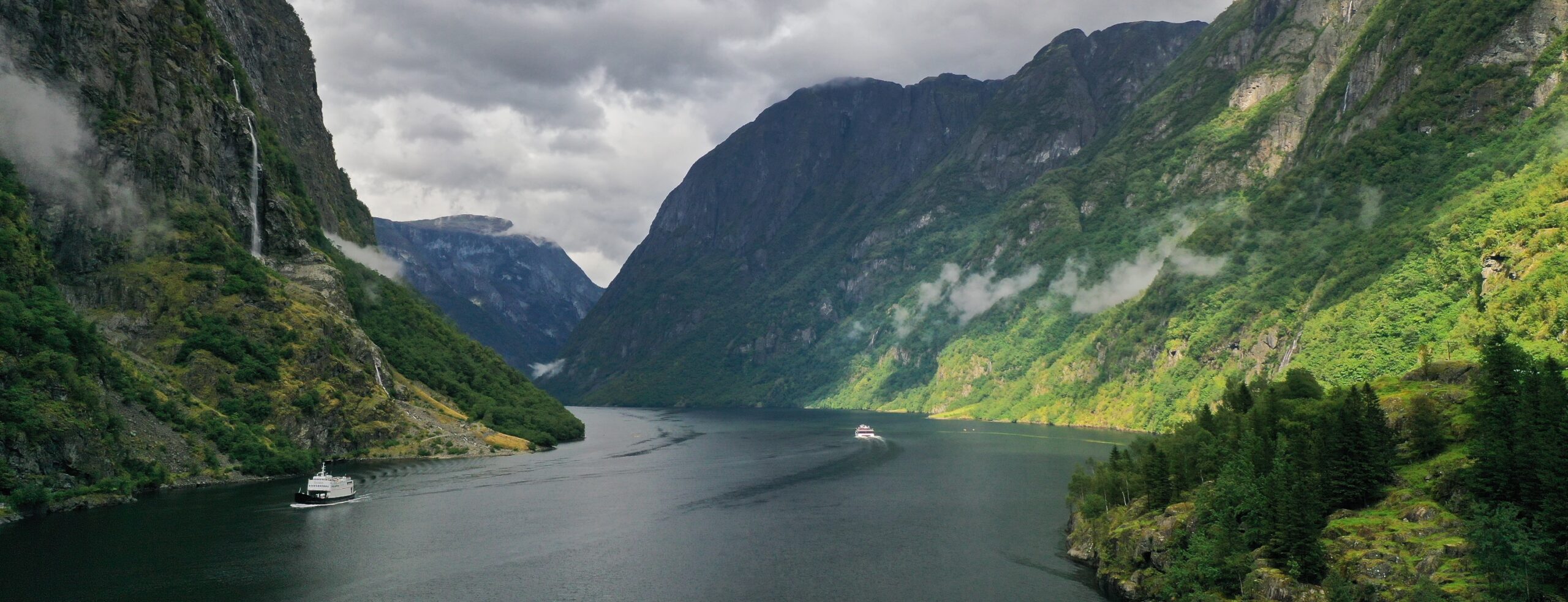
The Rimstigen Trail starts at Kvernaviki between Bakka and Tufto by the Nærøyfjord.
When we did the hike, we came from further out the Nærøyfjord in our kayaks, we had been staying overnight in our tent at Salthella Beach in the middle of the fjord.
The normal way is to drive five kilometers from Gudvangen at the innermost part of the Nærøyfjord towards Bakka further out the fjord.
There is a sign with directions and information about the hike just before you arrive the Tufteelvi River. There is a small parking lot at the starting point of the hike.

The Rimstigen Hike

The trail up to the Rimstigen Viewpoint is very steep, but the trail is normally in good condition with stairs of stones on parts of the trail. Due to the steep terrain, the trail goes in a zigzag pattern upwards on the south side of the Tufteelvi River which is a waterfall in the upper parts.
The trail are surrounded by forest in the lower part, but in some parts you can see the fjord. Further up there are less threes, and at the Rimstigen Viewpoint 725 meters above the fjord you are above the timberline. From there you have a fantastic view down to the Nærøyfjord and to the surrounding mountains.
The hike ends at the Rimstigen Viewpoint, and the return goes down on the same trail back to the starting point.
The hike to Rimstigen will take you around two to three hours one way. Remember to bring enough water, food and clothes on this hike. There are no rivers from where you can fill your bottles, it is too steep and dangerous terrain.
GUIDE – We recommend you to join a Guided Tour to Rimstigen. Fjord Tours arrange guided hikes to Rimstigen. See Fjord Tours website for booking and information about the hike and guiding season.
Christopher Seymour´s hike up Rimstigen
Christopher Seymour´s own words: – Join me as I hike to the top of Nærøyfjord on an exhausting and breathtaking trail. I fought through cold rain, intense elevation, blistering wind and I was rewarded by some of nature’s best views. This video is a true testament to hard-fought goals and the heart of landscape photography. Video: Christopher Seymour.
Gudvangen – Where the Vikings still live

Gudvangen is the innermost village by the beautiful and wild Nærøyfjord and is a perfect starting point for many great adventures in beautiful and wild nature.
Gudvangen is a perfect starting point for many great adventures in beautiful and wild nature. Gudvangen is a tiny village where the Nærøyfjord ends. The Nærøyfjord is a perfect base for adventures and nature experiences.
If you include the nearby area on and around the Aurlandsfjord, you can stay there for weeks and discover new and wonderful adventures every day.
Today you can visit the Viking Village Njardarheimr in Gudvangen and experience the real history and culture of the Viking age.

Aurlandsfjord and Nærøyfjord – What to See and Do
Flåm, Aurland and Gudvangen are perfect starting points for experiences and activities in and around the Aurlandsfjord and Nærøyfjord, two of the world’s most beautiful and dramatic fjords. On July 14, 2005, the Aurlandsfjord and Nærøyfjord and the surrounding area were inscribed on the UNESCO World Heritage List together with the Geirangerfjord. The Aurlandsfjord and Nærøyfjord are both branches of the 204 kilometer long Sognefjord, which is located in the middle of Western Norway.
Visit Sognefjord
Visit Sognefjord is the official destination company for the Aurlandsfjord, Nærøyfjord and Sognefjord area.
Hotels and accommodation in the Aurlandsfjord and Nærøyfjord area
Overview of hotels and other places where you can spend the night in the area around the Aurlandsfjord and Nærøyfjord.
Sakte – Stay and Explore the Aurlandsfjord and Nærøyfjord
“Sakte” is a collaboration between companies that provide adventures, accommodation, dining and short-travelled food- and products. “Sakte” are located in the area around the Aurlandsfjord and Nærøyfjord and is an offer for those who want to contribute to a sustainable society in the world heritage area.
