

There are eighteen National Tourist Routes in Norway. Ten of the roads are located in Western Norway, most of them along the beautiful and mighty fjords.
Common to them all is that the roads are going through some of the wildest and most beautiful scenery that Norway has to offer. Here is a brief overview of the National Tourist Routes in the fjords.
Season: Summer. This also depends on whether the winter-closed roads are open.
Below you can read more about what to see and do along the roads. There are great opportunities to not only see the area from the car, but also be active in the surrounding nature. Like hiking, cycling, skiing, glacier hiking or to join a fjord cruise. The pictures below show you some of the things you can do along the routes.
Fasten your seat belts and have a fabulous trip with beautiful scenery along the roads in the fjords.
The Atlantic Road

The Atlantic Road zigzags across low bridges that jut out over the Atlantic Ocean, linking the islands between Molde (famous for its annual jazz festival in July) and Kristiansund in the western fjords. The road is eight kilometer long and is voted as the construction of the century in Norway.
The Atlantic Road is part of a 36-kilometer long National Tourist Route between the towns of Kristiansund and Molde, the two main population centres in the county of Møre og Romsdal.
The eight kilometer long Atlantic Road runs from Kårvåg to Vevang, but the National Tourist Route continues along the Atlantic Coast to the fishing village of Bud. This is a beautiful road set in great surroundings with activities like fishing, diving and ocean safari which can all be done in the area.

You should take breaks if possible, to experience and explore the beautiful coastal nature. There are so many places along the road that are great to see. This part of Norway is great in beautiful weather, but is even better when the winter storms are at their most extreme.
A total of eight bridges are part of the road between Kårvåg and Vevang, the bridges traverses several small islands and reefs. The largest bridge and the most famous one is the 260 meter long Storseisundbrua Bridge.
There is also a parking place with a Service Building and Eldhuset Café at Eldhusøya Island close to Storseisundbrua Bridge. The Service Building and Café is open during the summer season, the toilet is open all year round.
An elevated trail takes you around the island, from the trail there is great view to the Atlantic Road, to Storseisundbrua Bridge and towards the Atlantic Ocean. Here you can explore what the Atlantic Coast have to offer.
Geiranger – Trollstigen

Experience the UNESCO-protected Geirangerfjord and the Trollstigen Mountain Road, two of Norways most dramatic and most visited attractions. Each year, hundreds of thousands tourists visit this area.
Drive to the viewpoints at Dalsnibba, Flydalsjuvet and Ørnesvingen (the Eagles Road) and see the view towards the Geirangerfjord and the surrounding mountains and waterfalls. Hike from Vesterås to Storseterfossen Waterfall or to Vesteråsen Viewpoint.
Stay at the Juvet Landscape Hotel at Gudbrandsjuvet that use the surrounding nature as part of the hotel.
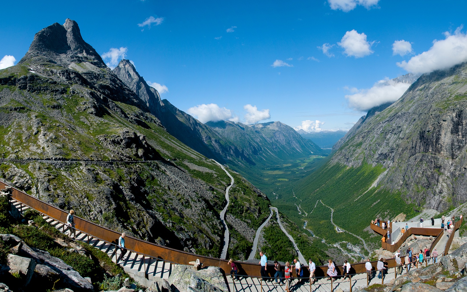
Trollstigen, 16 kilometers from Gudbrandsjuvet, is together with Geiranger one of the most visited attractions in Norway. The mountains which encircle the Trollstigen road are enormous. The Stigfossen Waterfall gushes down the mountainside towards the luscious Isterdalen Valley and in the middle of all this the Trollstigen Road winds its way up the mountainside. There are two viewpoints at Trollstigen only a few minutes walk from the road.
From Trollstigen it is only a short distance to Åndalsnes, a small town down by the Romsdalsfjord. Before arriving at Åndalsnes, drive eight kilometers up the Romsdalen Valley to the base of Mt Trollveggen and Romsdalshorn. From there there is a great view of the mountains, the valley and the Rauma river.
The National Tourist Route is 106 kilometer long and is closed during winter.
The Old Strynefjellet Mountain Road

Completed in 1894, the Old Strynefjell Mountain Road in Nordfjord was a masterpiece of road-building and engineering. This was the only way of passage between Skjåk and Stryn during most of the last century.
Stryn Summer Ski Centre is situated by this mountain road. Hjelle by Lake Oppstrynsvatnet is a beautiful village, just a short detour from the western part of the road.
Hjelle is a beautiful and quiet village down by Lake Oppstrynsvatnet. Here you have the beautiful historic Hjelle Hotel which is a great starting point for excursions around the Oppstryn, Stryn, Loen and Olden area.Gamlebutikken (The Old Shop) at Hjelle is situated down by the lake. The old shop is from 1882 and has been run by the same Hjelle family since the start.
Hjelle is located right down by Lake Oppstrynsvatnet and is a perfect place for activities on the water. Rowing, kayaking and SUP are great ways to experience the area.
The 27-kilometer long road is closed during winter.
The Gaularfjellet Mountain Road

The road over Gaularfjellet takes the traveller into the waterfalls in the mighty Sognefjord area, which is Norway’s longest and deepest fjord.
The viewpoint at Utsikten at the top of Gaularfjellet is one of many great viewpoints along this road which goes between Balestrand by the Sognefjord and Moskog and Sande in Sunnfjord.
Balestrand is one of the first places the foreign tourists visited when they discovered Norway in the mid-19th century. Due to the beautiful nature, the wild mountains and the location down by the fjord, Balestrand became a favorite place to visit among artists and the Norwegian and foreign society from the end of the 19th century until the beginning of World War I.

Germany´s Emperor Wilhelm II visited Balestrand several times, and it was an impressive sight when he entered the Sognefjord with his warships to spend his holidays there.
Well-known Norwegian painters such as Hans Dahl, Eilert Adelsteen Normann and Anders Askevold lived for long periods at Balestrand, and many of their most famous paintings have motifs from the Sognefjord and Balestrand area.
The 130 kilometer long drive is exciting and varied, and is closed during winter.
Sognefjellet Mountain Road

High in the Jotunheimen mountains, the Sognefjellet mountain road runs between the Lustrafjord and the Gudbrandsdalen Valley. The Sognefjellet National Tourist Route is the highest mountain pass in Northern Europe with its 1434 meters as its highest point.
From Skjolden you can drive into Fortun and further up the Sognefjellsvegen mountain road over to Lom in Gudbrandsdalen.
Located at 900 meters above sea level is Turtagrø Hotel, a new and modern mountain hotel where you can get information and guided hikes to Hurrungane, one of Norway’s wildest mountain areas.

Drive a little further and you have Sognefjellshytta Mountain Lodge on top of Sognefjellet. The mountain hut has a fantastic view towards the Smørstabbtindene mountains, to Mt Fannaråken and to the glaciers.
Just a few kilometers from Sognefjellshytta in the direction of Lom, you will arrive at Krossbu Fjellstue. They offer guided tours on the Smørstabbreen glacier.
The 106 kilometer long road is closed during winter.
The Aurlandsfjellet Mountain Road

The road across Aurlandsfjellet is a journey across a mountain landscape of snow and rocks with the occasional sprig of grass.
Aurlandsfjellet National Tourist Route is a 47-kilometer-long stretch of road between Aurland in the Aurlandsfjord area and Lærdal by the Sognefjord. Aurlandsfjellet Mountain Road is the starting point for many hikes in the area.

Stegastein Viewpoint is part of the road, 650 meters above Aurland and the Aurlandsfjord. Stegastein Viewpoint is a wooden platform, made of of glulam, which juts 30 meters out from the mountainside by the Aurlandsfjellet National Tourist Route. The panoramic view from Stegastein is one of the best views we have in the western part of Norway.
In winter, when the road over Aurlandsfjellet is closed, you can drive through the 24,509 meter long Lærdal tunnel from Lærdal to Aurland if you want to visit the area around the Aurlandsfjord and Nærøyfjord.
NOTE – The road from Aurland up to Stegastein is open all year, but in winter the road is closed between Stegastein Viewpoint above Aurland and Erdal by the Lærdalsfjord.
Hardanger National Tourist Route

The 158-kilometer-long Hardanger National Tourist Route passes through the scenic Hardangerfjord area, where for more than a century travellers have come to experience mountains, fjords, waterfalls and glaciers.
Parts of the Hardanger National Tourist Route runs along the east side of Sørfjorden, from the Låtefoss waterfall via Odda and Lofthus to Kinsarvik. The 38 kilometer long Sørfjorden is one of the many side fjords of the Hardangerfjord. Along Sørfjorden are small picturesque villages like pearls on a string, surrounded by fjords, mountains, waterfalls and rivers and not least all the fruit trees that are widely known for their beautiful blossoming in spring.
In the villages around Sørfjorden, there are cafés and restaurants and sales of produce from local orchards. On Taste Hardanger’s website, you get an overview of the many fruit and cider farms that you can visit. Most of them are located around Sørfjorden.

There is also a separate Cider Cruise on Sørfjorden, where you can combine a fjord cruise with a visit to some of the farms and taste the local cider products. Remember that if you want to visit local cider producers, you must book this in advance.
Two great hikes in the area are the hikes to Trolltunga with start from Skjeggedal and the HM Queen Sonja´s Panoramic Trail between Kinsarvik and Lofthus. The area offers many opportunities for hiking, outdoor adventure and culture experiences.
INFORMATION ABOUT THE ROADS IN HARDANGER – Many of the roads in Western Norway can be prone to landslides and avalanches, especially in rainy and snowy weather. The roads in Hardanger and along the Sørfjorden are some of these exposed roads. In many places, there is only room for one vehicle in width. You have to drive carefully and be prepared to stop and reverse to the nearest meeting place. Note that parts of the Skjervsvegen road are closed in winter, there is no access to Skjervsfossen waterfall then.
Hardangervidda National Tourist Route

The 67 kilometer long Hardangervidda National Tourist Route runs through Hardangervidda National Park, which is Northern Europe’s largest mountain plateau.
The Måbødalen valley and Vøringsfossen Waterfall are two tourist attractions you can see from the road. Vøringsfossen, which falls into Måbødalen, is Norway’s most famous waterfall.
You can drive to the viewpoints and see Vøringsfossen and the other waterfalls from above. You can park the car in the car park on the south side of Fossli Hotel.

A new viewing platform and a viewing bridge above the Vøringsfossen Waterfall has been constructed in conjunction with the Hardangervidda National Tourist Route. There is a short walk to both of those viewpoints from the parking lot.
SEASON Viewing Platform – June to September, depending on temperature and snow. NOTE – You should never walk on the viewing platforms and the bridge if there are snow and ice, this is not safe!
There might be a chance that the road is closed in short periods during winter.
Ryfylke National Tourist Route

At Ryfylke, idyllic green skerries and cultural landscapes are suddenly replaced by rockslides, polished cliffs, mountains and fjords. Along the 183-kilometer long Ryfylke National Tourist Route you pass villages, towns and cultural attractions.
How about a small detour including a mountain hike to Mt Preikestolen with a panoramic view of the Lysefjord? The hike to Preikestolen starts at Preikestolen Fjellstue and there is a marked trail to the mountain plateau. The four kilometer long hike and 330 meter climb takes about two to three hours each way. Preikestolen is a popular destination for both Norwegians and foreign visitors. In high season, it can be crowded on the flat mountain plateau, which measures only 25 by 25 meters and with three of the edges going vertically down into the Lysefjord.

Lovra viewpoint is part of the Ryfylke National Tourist Route. It can be reached by walking along a short trail that starts by the road. On the other side of the fjord, at the southernmost end of Lovrafjorden, is probably the most popular place to take pictures of Eiaholmen. The small island of Eiaholmen in Lovrafjorden in Sand in Ryfylke is a popular spot for Instagrammers and other keen photographers.
The drive along Ryfylke National Tourist Route is also a drive through the Norwegian industrial history.
Parts of the Ryfylke National Tourist Route is closed during winter.
Jæren National Tourist Route

Jæren – with open skies, wide horizons and endless ocean. Mile upon mile of sandy beaches and sand dunes.
Jæren is widely known for being Norway’s food basket, but just as well known are the wonderful beaches that lie there in a row. The beaches are used for recreation, swimming, surfing and other activities. Remember sunscreen with a high factor.

The most famous beaches are (from the north) Solastranden, Hellestøstranden, Borestranden and Orrestranden.
The Jæren National Tourist Route is a 130 kilometer stretch of road between Bore on Jæren and Flekkefjord in Agder.
The road runs through Norway’s food basket with intensive agriculture in a flat, large and well-maintained cultural landscape.
National Tourist Routes in Norway – Useful Links